A contractor working on a multi-storey mixed-use project near Brock Street South hit something unexpected at 4.5 metres down: fractured shale with groundwater seeping in faster than the sump pumps could handle. That kind of scenario plays out more often than people think in Whitby, where the geology shifts from stiff glacial till to Queenston Formation shale within a few hundred metres. The excavation monitoring program on that job had to adapt overnight—adding extra piezometer readings and tightening the vibration thresholds for the neighbouring heritage building. Monitoring a deep cut here is never just about checking a settlement point once a week. It requires understanding how Lake Ontario’s shoreline bluffs, seasonal frost penetration, and urban fill layers interact when you open up the ground. For projects near the 401 corridor or the waterfront, we combine continuous inclinometer data with deep excavation instrumentation to track lateral movement before it becomes a problem, and we often pair that with retaining wall monitoring when shoring systems are tied back into sensitive right-of-way zones.
In Whitby’s mixed till-and-shale profile, real-time excavation monitoring catches the subtle movements that visual inspections miss.
Technical details of the service in Whitby
Typical technical challenges in Whitby
Whitby’s position on the Lake Ontario shoreline means groundwater isn’t just a single-table problem—it fluctuates seasonally and responds to storm events in ways that can surprise even experienced crews. A cut that stays dry through August can start weeping in November when the water table rebounds. Then there’s the shale: Queenston Formation bedrock weathers quickly when exposed to air and moisture, losing strength over days rather than weeks. If monitoring stops once the excavation reaches grade, you miss the progressive degradation that can undermine a footing before concrete is poured. The other big variable here is vibration from urban sources—heavy trucks on Dundas Street, GO Transit rail traffic, even the pulse from nearby pile driving can accumulate effects on a shoring system. Without continuous vibration and tilt monitoring, you’re essentially running a blind experiment on a multimillion-dollar hole in the ground. The Ontario Building Code references these geotechnical risks explicitly, and municipal permit reviewers in Durham Region expect to see a monitoring specification that addresses them point by point.
Our services
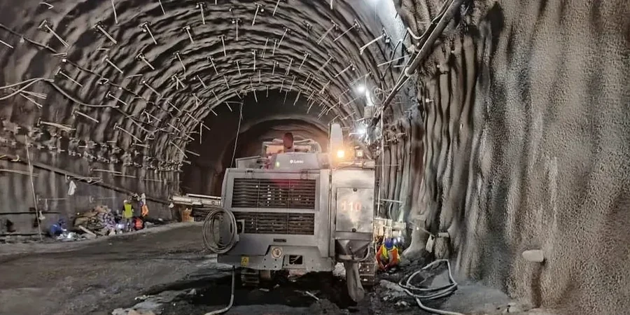
Excavation monitoring in Whitby covers more than just reading instruments. The programs we run address the specific challenges of Durham Region’s geology and regulatory environment.
Deep Excavation Instrumentation
Comprehensive monitoring for cuts exceeding 4.5 metres in Whitby’s till and shale. Includes inclinometer casings installed into bedrock, multi-point settlement arrays along adjacent roadways and utilities, and automated total station networks that track building movement during shoring installation and bulk excavation.
Vibration and Groundwater Control
Specialized vibration monitoring using triaxial geophones for projects near Whitby’s heritage district, GO Transit rail corridor, and sensitive infrastructure. Combined with real-time vibrating wire piezometers and standpipe monitoring to manage dewatering effects on neighbouring properties and the Lake Ontario shoreline aquifer.
Frequently asked questions
What does a Whitby excavation monitoring program typically cost?
Programs generally range from CA$1,000 for short-term, single-parameter monitoring on a small residential lot up to CA$3,870 for comprehensive multi-instrument setups on deep commercial excavations. The final figure depends on cut depth, number of adjacent structures, monitoring duration, and whether automated real-time data acquisition is required versus manual readings.
When is monitoring mandatory for an excavation in Whitby?
Monitoring becomes mandatory under the Ontario Building Code when an excavation extends below the zone of influence of adjacent buildings, public right-of-ways, or utilities. The Town of Whitby and Durham Region building departments will typically require a monitoring specification as part of the shoring permit package when cuts exceed 3 metres near sensitive structures or 6 metres in open areas.
What instruments do you install for a typical deep dig in Whitby?
A standard program includes inclinometers to track lateral shoring movement, settlement points or optical prisms on nearby buildings and roads, vibrating wire piezometers for groundwater pressure at multiple depths, and crack gauges on any masonry within the predicted settlement trough. Vibration monitors get added when rock excavation or pile driving is planned near occupied structures.
How often should readings be taken during excavation?
During active digging near Whitby's shale bedrock, daily readings are standard for settlement and inclinometer points, with vibration monitoring run continuously when rock breaking is underway. The frequency can step down to weekly once the cut reaches grade and movement stabilizes, but we maintain at least bi-weekly checks until permanent works are in place and backfilling is complete.